The Baby Boomers rebelled against their dorky parents. We Gen Xers, however, couldn't rebel against our parents since rebelling against your parents had been done, so instead, we cultivated irony; it was all we could do. This subtle, handcrafted irony, however, has fallen into the hands of subsequent generations who have been misinterpreting ever since, and now we have dorky a cappella singing competitions on TV. Ironically, that's what happens when you try to be ironic — you end up making things a million times worse. Therefore, all intentional irony should be abolished until everyone's clear on what's good and what's bad. It'll probably take about five years.
2. Being All Ghetto
Getting your drink on, making it rain up in here, giving a shout out, being all about things, and throwing gang signs in pictures are all about 15 years out of date and weren't that great to begin with. Classically, a ghetto is a tragic place from which to emerge, not dive into and declare fabulous.
3. Stepping Up Your Game and/or Bringing Your A-Game
Just forget about your game completely.
4. The Namaste Gesture
When directed at, let's say, the dry cleaner, this abridged prayer and bow combo comes off as highly insincere. As with everything, if you can imagine Adam Levine doing it, you should avoid it.
5. Being Stoked
All too often, being stoked leads to giving a shout out. Best to avoid it.
6. Giving It Up
Conversely, giving it up for someone or something often succeeds giving a shout out, and should also be avoided.
7-9. Honoring Yourself, Practicing Mindfulness, and Manifesting What the Universe Wants for You
Over, over, over.
10. Chillaxing
Oh, don't feel bad for chillaxing. It had a good run.
11. The Falsetto Flourish
The advent of You Tube, Funny or Die, and other such do-it-yourself comedy outlets has had the odd effect of turning everyone into Jack Black. Saying something like, "I'mo get mydrink on" with the "drink on" part sung in falsetto is a stylistic choice that cannot carry over into the new year. It might not seem like much now, but after a while, when things start to seem somehow better, we'll know it's because the Falsetto Flourish is gone.
12. Strong, Amazing Woman
It's become increasingly rare to hear women described without these two pat qualifiers. Maybe we could come up with two other ones, or maybe — better yet — we could let the strength and amazing-ness of women be quietly understood in a way that is truly strong and amazing. In the meantime, here's what you can say when describing a woman: "I want you to meet my friend Donna. She's really great."
13. Inventive Uses for "Much"
As in, "not so much" and "_____ much?" They may have been delightfully fresh in the '90s, but when your idioms are used to sell fast food and car insurance, it's time to abandon them.
14. Literally
Since "literally" can now mean "figuratively," we must stop interjecting it into our conversations in favor of the latter. Let's see if we now can get "figuratively" to mean "literally." Wouldn't that be great? We should figuratively do that.
15. Hey Lady
"Hey lady" has become the new "In the future" — a phrase that signifies something you don't want to hear. If I get an email that begins, "Hey lady," I delete it unread.
16. Being a Hater
Feel free to do it, just don't say it.
17. The Baby Clap Gesture
This stiff-handed, largely silent, staccato clap gesture that is often accompanied by a soft "Yay" (see below) stands in direct contrast to everything a clap should be. It's really goofing up clapping, and once clapping goes, we're doomed.
18. Right Now
As in, "Are you kidding me right now?" and "Are you serious right now?" A totally unnecessary utterance that takes time away from constantly saying "figuratively."
19. Awesomeness
The unauthorized noun-ification of a dead adjective. Lose both.
20. At the End of the Day, It Is What It Is.
Across this great land, roughly 500,000 times a day, one person says this to another person, who nods in agreement, neither of them realizing that they've just participated in the emptiest experience two people can have. No more.
21. Gamechanger
As previously stated, please delete all references to one's game.
22-25. Wheelhouse, Random, Bow Chica Wow Wow, and I Know, Right?
For obvious reasons.
26. Yay!
Perhaps it's because everyone's so thrilled about everything that this once vibrant exclamation has grown feeble. If we're going to talk like children, I propose we say, "Goody goody gumdrops!" It's just as dumb, but at least it's different.
27. Calling Something the Best _____ Ever
You can still do this as long as you only do it once in your life. Only one thing can be the best thing ever, so you'd better think long and hard about that scone before you open your mouth.
Iran's President Hassan Rouhani takes questions from journalists during a news conference in New York September 27, 2013.
Iranian President Hassan Rouhani says he wants to rebuild diplomatic relations with Western powers, even as he insists the country will “never never give up our right to nuclear energy.” Rouhani’s comments, in an editorial in a German newspaper Monday and
accompanying Twitter messages on an account associated with him, came
during a Christmas break in talks over Iran’s nuclear program. “We want to rebuild and improve our relations to European and North
American countries on a basis of mutual respect,” Rouhani wrote in the Sueddeutsche Zeitung
newspaper, Reuters reports. “We are striving to avoid new burdens on
relations between Iran and the United States and also to remove the
tensions that we have inherited. “We must now concentrate on the present and orientate ourselves
towards the future,” read the messages on a closely-followed Twitter
account that has never been verified as belonging to Rouhani but has
broken news of his policy positions and actions before. “We’ll never
give up our right to #nuclear energy. But we’re working towards removing all doubts and answer all reasonable questions.” Rouhani helped spearhead the landmark negotiations over Tehran’s
nuclear program. The temporary deal reached last month allows for
crippling economy sanctions on Iran’s economy to be lifted and the
country to halt its nuclear program for six months while negotiators try
to hash out a more permanent agreement. Diplomats announced Sunday that
Geneva talks will be suspended until after Christmas.
The rendering of America and Africa in Martin Waldseemuller's 1507 world map (Wikimedia Commons)
In June 2012, Brian McClendon, an executive at Google, announced that Google Maps and Google Earth were part of a far loftier pursuit than edging out Apple and Facebook in the map services market. Google, McClendon wrote in a blog post, was engaged in nothing less than a "never-ending quest for the perfect map."
"We’ve been building a comprehensive base map of the entire globe—based on public and commercial data, imagery from every level (satellite, aerial and street level) and the collective knowledge of our millions of users," McClendon noted. By strapping cameras to the backs of intrepid hikers, mobilizing users to fact-check map data, and modeling the world in 3D, he added, Google was moving one step closer to mapmaking perfection.
It was the kind of technological triumphalism that Jerry Brotton would likely greet with a knowing smile.
"All cultures have always believed that the map they valorize is real and true and objective and transparent," Brotton, a professor of Renaissance studies at Queen Mary University of London, told me. "All maps are always subjective.... Even today’s online geospatial applications on all your mobile devices and tablets, be they produced by Google or Apple or whoever, are still to some extent subjective maps."
There are, in other words, no perfect maps—just maps that (more-or-less) perfectly capture our understanding of the world at discrete moments in time. In his new book, A History of the World in 12 Maps, Brotton masterfully catalogs the maps that tell us most about pivotal periods in human history. I asked him to walk me through the 12 maps he selected (you can click on each map below to enlarge it).
A 15th-century reconstruction based on Ptolemy's projections of the world (Wikimedia Commons)
Humans have been sketching maps for millennia, but Claudius Ptolemy was the first to use math and geometry to develop a manual for how to map the planet using a rectangle and intersecting lines—one that resurfaced in 13th-century Byzantium and was used until the early 17th century. The Alexandria-based Greek scholar, who may never have drawn a map himself, described the latitude and longitude of more than 8,000 locations in Europe, Asia, and Africa, projecting a north-oriented, Mediterranean-focused world that was missing the Americas, Australasia, southern Africa (you can see Africa skirting the bottom of the map and then blending into Asia), the Far East, the Pacific Ocean, and most of the Atlantic Ocean. Ptolemy'sGeography was a "book with a 1,500-year legacy," Brotton says.
2. Cultural Exchange: Al-Idrisi'sWorld Map (1154)
Wikimedia Commons
Al-Sharif al-Idrisi, a Muslim from Al-Andalus, traveled to Sicily to work for the Norman King Roger II, producing an Arabic-language geography guide that drew on Jewish, Greek, Christian, and Islamic traditions and contained two world maps: the small, circular one above, and 70 regional maps that could be stitched together. Unlike east-oriented Christian world maps at the time, al-Idrisi's map puts south at top in the tradition of Muslim mapmakers, who considered Mecca due south (Africa is the crescent-shaped landmass at top, and the Arabian Peninsula is in the center). Unlike Ptolemy, al-Idrisi depicted a circumnavigable Africa—blue sea surrounds the globe. Ultimately, the map is concerned with representing physical geography and blending traditions—not mathematics or religion. "There are no monsters on his maps," Brotton says.
3. Christian Faith: Hereford's Mappa Mundi (1300)
Wikimedia Commons
This map from England's Hereford Cathedral depicts "what the world looked like to medieval Christians," Brotton says. The organizing principle in the east-oriented map is time, not space, and specifically biblical time; with Christ looming over the globe, the viewer travels spiritually from the Garden of Eden at top down to the Pillars of Hercules near the Strait of Gibralter at bottom (for a more detailed tour, check out this handy guide to the map's landmarks). At the center is Jerusalem, marked with a crucifix, and to the right is Africa, whose coast is dotted with grotesque monsters in the margins. "Once you get to the edges of what you know, those are dangerous places," Brotton explains.
What's most striking about this Korean map, designed by a team of royal astronomers led by Kwon Kun, is that north is at top. "It's strange because the first map that looks recognizable to us as a Western map is a map from Korea in 1402," Brotton notes. He chalks this up to power politics in the region at the time. "In South Asian and Chinese imperial ideology, you look up northwards in respect to the emperor, and the emperor looks south to his subjects," Brotton explains. Europe is a "tiny, barbaric speck" in the upper left, with a circumnavigable Africa below (it's unclear whether the dark shading in the middle of Africa represents a lake or a desert). The Arabian Peninsula is to Africa's right, and India is barely visible. China is the gigantic blob at the center of the map, with Korea, looking disproportionately large, to its right and the island of Japan in the bottom right.
This work by the German cartographer Martin Waldseemuller is considered the most expensive map in the world because, as Brotton notes, it is "America's birth certificate"—a distinction that prompted the Library of Congress to buy it from a German prince for $10 million. It is the first map to recognize the Pacific Ocean and the separate continent of "America," which Waldseemuller named in honor of the then-still-living Amerigo Vespucci, who identified the Americas as a distinct landmass (Vespucci and Ptolemy appear at the top of the map). The map consists of 12 woodcuts and incorporates many of the latest discoveries by European explorers (you get the sense that the woodcutter was asked at the last minute to make room for the Cape of Good Hope). "This is the moment when the world goes bang, and all these discoveries are made over a short period of time," Brotton says.
6. Politicized Geography: Ribeiro's World Map (1529)
Wikimedia Commons
The Portuguese cartographer Diogo Ribeiro composed this map amid a bitter dispute between Spain and Portugal over the Moluccas, an island chain in present-day Indonesia and hub for the spice trade (in 1494, the two countries had signed a treaty dividing the world's newly discovered lands in two). After Ferdinand Magellan's expedition circumnavigated the globe for the first time in 1522, Ribeiro, working for the Spanish crown, placed the "Spice Islands," inaccurately, just inside the Spanish half of his seemingly scientific world maps. Ribeiro may have known that the islands (which appear on the far-left and far-right sides of the map) actually belonged to Portugal, but he also knew who paid the bills. "This is the first great example of politics manipulating geography," Brotton says.
7. Territorial Navigation: Mercator's World Map (1569)
Wikimedia Commons
Next to Ptolemy, Brotton says, Gerardus Mercator is the most influential figure in the history of mapmaking. The Flemish-German cartographer tried "on a flat piece of paper to mimic the curvature of the earth’s surface," permitting "him to draw a straight line from, say, Lisbon to the West Coast of the States and maintain an active line of bearing." Mercator, who was imprisoned by Catholic authorities for alleged Lutheran heresy, designed his map for European navigators. But Brotton thinks it had a higher purpose as well. "I think it’s a map about stoicism and transcendence," he says. "If you look at the world from several thousands miles up, at all these conflicts in religious and political life, you’re like ants running around." Mercator has been accused of Eurocentrism, since his projection, which is still occasionally used today, increasingly distorts territory as you go further north and south from the equator. Brotton dismisses this view, arguing that Europe isn't even at the center of the map.
8. Commercial Cartography: Blaeu's Atlas maior (1662)
Viking/Penguin
Working for the Dutch East India Company, Joan Blaeu produced a vast atlas with hundreds of baroque maps gracing thousands of pages. "He's the last of a tradition: the single, brilliant, magician-like mapmaker who says, 'I can magically show you the entire world,'" Brotton says. "By the late 17th century, with joint stock companies mapping every corner of the world, anonymous teams of people are crunching data and producing maps." Blaeu's market-oriented maps weren't cutting-edge. But he did break with a mapmaking tradition dating back to Ptolemy of placing the earth at the center of the universe. At the top of the map, the sun is at the center of personifications of the five known planets at the time—in a nod to Copernicus's theory of the cosmos, even as the earth, divided into two hemispheres, remains at the center of the map, in deference to Ptolemy (Ptolemy is in the upper left, and Copernicus in the upper right). "Blau quietly, cautiously says I think Copernicus is probably right," Brotton says.
9. National Mapping: Cassini's Map of France (1744)
Library of Congress
Beginning under Louis XIV, four generations of the Cassini family presided over the first attempt to survey and map every meter of a country. The Cassinis used the science of triangulation to create this nearly 200-sheet topographic map, which French revolutionaries nationalized in the late 18th century. This, Brotton says, "is the birth of what we understand as modern nation-state mapping ... whereas, before, mapmaking was in private hands. Now, in the Google era, mapmaking is again going into private hands."
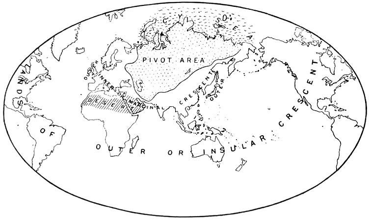
10. Geopolitics: Mackinder's 'Geographical Pivot of History' (1904)
Viking/Penguin
Don't let the modesty of this "little line drawing" fool you, Brotton says: It "basically created the whole notion that politics is driven to some extent by geographic issues." The English geographer and imperialist Halford Mackinder included the drawing in a paper arguing that Russia and Central Asia constituted "the pivot of the world's politics." Brotton believes this idea—that control of certain pivotal regions can translate into international hegemony—has influenced figures ranging from the Nazis to George Orwell to Henry Kissinger.
11. Geoactivism: Peters's Projection (1973)
Wikimedia Commons
In 1973, the left-wing German historian Arno Peters unveiled an alternative to Mercator's allegedly Eurocentric projection: a world map depicting countries and continents according to their actual surface area—hence the smaller-than-expected northern continents, and Africa and South America appearing, in Brotton's words, "like long, distended tear drops." The 'equal area' projection, which was nearly identical to an earlier design by the Scottish clergyman James Gall, was a hit with the press and progressive NGOs. But critics argued that any projection of a spherical surface onto a plane surface involves distortions, and that Peters had amplified these by committing serious mathematical errors. "No map is any better or worse than any other map," Brotton says. "It's just about what agenda it pursues."
The West Wing enshrined the Peters Projection in pop culture during an episode in which the fictitious Organization of Cartographers for Social Equality lobbies the White House to make it mandatory for public schools to teach Peters's map rather than Mercator's.
12. Virtual Mapping: Google Earth (2005)
Google is at the forefront of innovations in digital mapmaking, Brotton says. But he also notes that the company sees maps as an adjunct to search and advertising. "My question is what gets on maps, who pays to get on maps now, and who can't pay and is therefore not on maps?" he asks. Back in Mercator's day, source code consisted of the projection the cartographer used and the data he fed into it. Now, Brotton notes, we don't know what source code Google and other online mapping applications are using. And this at a time when Google, which offers users more than 20 petabytes of imagery, is working with far more material than a country can match. "Companies can now produce maps in more detail than, say, the U.K. Ordnance Survey, but without any peer-observation process," Brotton asserts.
"We always get the map that our age deserves," he adds.
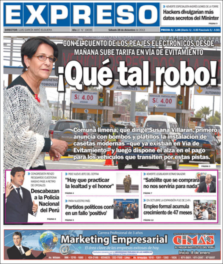
POR REYNA CÁRDENAS A.
Y sigue subiendo. Horas después que el Concejo capitalino, que lidera
Susana Villarán de la Puente, anunciara la instalación de los llamados
“peajes electrónicos” que reducirían significativamente el tiempo de
tránsito en la Vía de Evitamiento, un comunicado de Línea Amarilla SAC
anuncia el alza de las tarifas para los vehículos que transitan por esta
autopista.
Y es que según la concesionaria de Vía Parque Rímac, el incremento
estaba contemplado desde octubre último, cuando se reajustaron las tasas
para vehículos particulares de S/. 3 a S/. 4, mientras que para los
buses y camiones se pasó de S/. 2,50 a S/. 3 por eje, respectivamente.
“La unificación consiste en uniformizar el monto de los precios para
todo tipo de transporte. Esta medida corresponde a la aplicación del
contrato de concesión firmado en noviembre de 2009”, señala la nota de
prensa de Línea Amarilla.
Se señala además que la tasa se aplica a los vehículos de transporte
ligero, pesado y público que se trasladen por la Vía de Evitamiento,
comprendida desde el tramo Trébol de Javier Prado hasta el Óvalo Habich.
Por ello, desde mañana 29 de diciembre regirán las siguientes tarifas: 4
soles para vehículos de transporte público ligero (antes 3 soles), 4
soles por eje, vehículos de transporte pesado, tanto público como de
carga (antes 3 soles), y para transporte público seguirá siendo 4 soles
de peaje por unidad. ¿Y la novedad?
Respecto al sistema de peaje electrónico implementado en la Vía de
Evitamiento por el consorcio Vía Parque Rímac, concesionaria de la
Municipalidad de Lima, este no sería nuevo para el país y menos para la
capital, pues este ya había sido puesto en funcionamiento desde el 2004
por Emape, aunque bajo una modalidad distinta.
Así lo dijo a EXPRESO el ex gerente de dicha entidad, Armando Molina,
quien explicó con respecto a dicho modelo de recaudación que este ya se
aplicaba desde aquel año a algunos vehículos de carga y particulares de
modo corporativo, para lo cual se les otorgaba unos códigos en tarjetas
que podían pegar en los parabrisas.
El pago no se realizaba previamente, como ocurre con el actual sistema,
sino que el costo se cargaba al sistema en cada paso por el peaje y
luego, en forma quincenal o mensual, de acuerdo a su consumo, los
usuarios efectuaban el pago.
“Lo que están haciendo ellos (la concesionaria) es presentar un modelo
similar al que ya funcionaba como si fuera una novedad, al igual que las
cámaras de seguridad ciudadana. Estas cámaras están en Evitamiento
desde el 2004 y esta empresa las ha presentado nuevamente a mediados de
este año como si fuera una innovación. Creen que los limeños no nos
damos cuenta de lo que ya había, de lo que hay y de lo que no hay”,
sostuvo. ¿Y las obras de Villarán?
Armando Molina lamentó la carencia de obras de la gestión que dirige
Susana Villarán, y atribuyó a ello el lanzamiento con bombos y platillos
de cualquier cambio que se dé en Lima, como el supuesto nuevo sistema
de cobro por peajes electrónico.
“Al parecer la Municipalidad de Lima no tiene una sola obra qué
mostrar, qué entregar a la población porque, así como hicieron con las
escaleras amarillas, que las pintaron de verde y las presentaron como si
fueran nuevas, están haciendo lo mismo con las cámaras y el peaje”,
agregó.
Molina cuestionó además que la empresa a cargo de los peajes haya
gastado en colocar grandes bloques de concreto y estructuras metálicas
en los peajes en vez de invertir en la limpieza, iluminación y otras
obras necesarias para esta importante vía. “Hoy Evitamiento ya ni
siquiera tiene áreas verdes”, apuntó.
Campion Marine develops 180 hp electric outboard that doesn’t make a peep.
By: Rodger McAfee
A small Canadian boat builder, using the expertise of a Florida-based
marine electrical firm, has developed the world’s most powerful electric
outboard motor. Now in its 40th year of operation, Campion Marine
(campionboats.com) of Kelowna, B.C., unveiled its 180 hp (135 kw)
electric outboard, and we were invited for a test. Ft. Lauderdale’s
ReGen Nautic USA Inc. was contracted to provide the electrical and
electronic technology.
Except for the striking graphics, the engine looked the same as any
other outboard, and there’s a good reason for that: It started life as a
four-stroke gasoline-powered Yamaha 150. The gasoline powerhead was
replaced by a 180 hp electric motor and its necessary electronic
controllers, yielding weight savings of about 100 pounds.
Campion clamped the outboard — the E Fusion — onto one of its
favorite test models, a 2,000-pound Chase 550, which is the same model
Campion used as a test boat for its bio-resin experiment three years
ago. It worked so well that Campion now builds its entire line of boats
using bio-resin rather than petro-resin.
The 550 is a racy-looking 18-foot bowrider with a beam of 7 feet, 8
inches and is Coast Guard approved for eight people. It has a 19-degree
deadrise at the transom and normally carries about 175 pounds of
gasoline, but no gas was needed with an electric outboard hung on the
transom. The boat and motor combination weighed about 275 pounds less
than a gas-operated setup.
However, batteries added 600 pounds, so the boat as we ran it weighed about 2,300 pounds.
Testing an electric outboard is a different experience. With a gas
setup, we usually turn the key, start the engine and let it settle down,
and then let it warm up for a couple of minutes before leaving the
dock. With the E Fusion, we turned the key and left the dock. Without
any sound.
The control system operates the same as it does on a gas outboard.
Push the control lever forward, and the boat moves forward. Push it
farther forward, and the boat goes faster forward. Pull the lever aft,
and the boat goes in reverse; pull farther aft, and it goes faster in
reverse.
We cleared the dock and shoved the throttle fully forward. In just a
hair more than three seconds, we were on plane. And we had 1,000 pounds
of writers, cameras and a boat operator on board. With only three people
on board, time to plane was 2.9 seconds. The electric outboard popped
the boat on plane faster than a gas outboard I tested previously on a
550. We went from 0-30 mph in four seconds.
During separate testing, Campion reported a top speed of 50 mph, and
even with all the extra weight on board we came close to that. The only
noise was the sound of the wind whipping past our ears and the water
slapping against the hull. With the vessel at WOT, 6000 rpm, I reached
back and put my hand on the outboard. It was silky smooth. We put the
boat through the usual quick turns and a bit of wake leaping, and it
behaved the same as it did with a gas outboard.
The 400v battery pack is assembled by ReGen Nautic using a number of 3.2v cells.
“We custom assemble the battery to fit the builder’s space
requirement,” said ReGen’s Jean-Marc Zanni. “Our design also ensures
that no one on board can come in contact with the battery or battery
cabling.”
The electric powerhead is jacketed, and the heat exchanger is cooled. The electronic controls are air cooled.
Running time at about 45 mph has been about two hours during testing.
Recharge time, using standard household 220v 15-amp service (the boat
is rigged for 220, because it has been sold to a European buyer), is
about eight hours. However, with 220v 50-amp service, charging time is
cut in half. If 440v three-phase power is available, charging time can
be as little as 20 minutes. In the case of rapid charging, a different
onboard charger is required.
Product Description
We now have the Electric 180 hp as a fully functional electric propulsion system that comprises the following:
A 110 pound permanent magnet brushless electric motor and controller
Cooling heat exchanger and associated pump
A helm display and intelligent computer interface
A medium voltage safety and switching unit
A medium voltage charging unit
Battery Management System
A high C rated, lithium battery bank.
*The 300HP version will be released summer 2013 ____________________________________________________________________________________________
A 180 HP eFusion version as developed for Campion Marine of Kelowna BC, Canada


 The Atlantio
 A 15th-century reconstruction based on Ptolemy's projections of the world (Wikimedia Commons)
 Wikimedia Commons


